EIT Climate-KIC supported geoFootprint launched a new tool to accelerate sustainable agriculture

Supported by EIT Climate-KIC and developed by its partner Quantis, geoFootprint recently launched a sustainable agriculture tool.
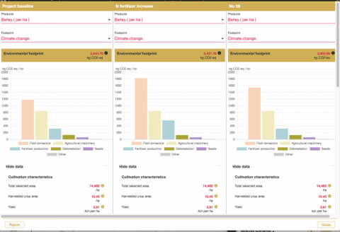
The tool combines data from satellite imagery with environmental metrics, allowing users to visualise the footprints of key commodity crops on an interactive world map at high resolution.
Agriculture is responsible for over 20 per cent of global greenhouse gas emissions. The complex, globalised nature of agricultural supply chains presents a massive data management challenge for companies: Crops are traded globally, but their footprints are calculated locally.
To reduce their footprint and meet ambitious targets like carbon neutrality, companies need to first understand the impact of how their crops are grown and managed.
With geoFootprint, companies and stakeholders across the supply chain can now instantly simulate the environmental footprints of crops, bringing visibility to on-the-farm and upstream impacts (deforestation, fertiliser use, irrigation, land management and other factors), allowing for faster, better-informed and more sustainable decision making. Moreover, geoFootprint enables users to assess the risks posed by changes in climate, water availability and quality, soil health, and biodiversity to secure supply chains and the future of food.
While agriculture is one of the largest contributors to the climate and biodiversity crisis, it also represents one of the most high-potential solutions. geoFootprint enables companies to reduce the environmental footprint of crops in their supply chains through providing insights that—until now have been nearly impossible to capture. It fills a giant knowledge gap that will allow us to accelerate the sustainable transformation of agriculture.
Xavier Bengoa, geoFootprint project lead and a senior sustainability consultant at Quantis
An open-access version of geoFootprint is available for non-expert audiences, students and other stakeholders to expand public knowledge on sustainable agriculture and the crop production risks posed by climate change.
A multi-stakeholder initiative, geoFootprint was built collaboratively with more than 25 public, private and academic partners aiming to accelerate sustainable agriculture through innovation.


 Share this page


